
Make a donation
Gear up for your next adventure:
As an Amazon Associate, this site earns from qualifying purchases at no extra cost to you.
Brunnen topographic map
Click on the map to display elevation.
Make a donation
Gear up for your next adventure:
As an Amazon Associate, this site earns from qualifying purchases at no extra cost to you.
About this map
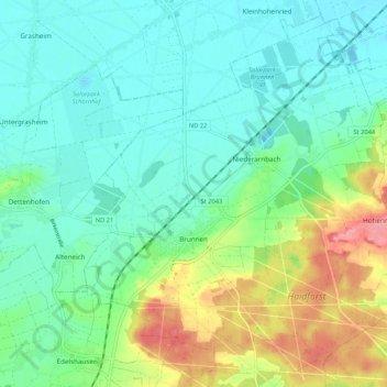
Name: Brunnen topographic map, elevation, terrain.
Average elevation: 399 m
Minimum elevation: 371 m
Maximum elevation: 470 m
Make a donation
Gear up for your next adventure:
As an Amazon Associate, this site earns from qualifying purchases at no extra cost to you.
Other topographic maps
Click on a map to view its topography, its elevation and its terrain.
Schloss Sinning
Germany > Bavaria > Landkreis Neuburg-Schrobenhausen > Sinning
Average elevation: 432 m
Zell
Germany > Bavaria > Landkreis Neuburg-Schrobenhausen > Neuburg an der Donau
Average elevation: 379 m
Make a donation
Gear up for your next adventure:
As an Amazon Associate, this site earns from qualifying purchases at no extra cost to you.