
Thank you for supporting this site ❤️
Make a donation
Make a donation
Gear up for your next adventure:
As an Amazon Associate, this site earns from qualifying purchases at no extra cost to you.
Huacan topographic map
Click on the map to display elevation.
Thank you for supporting this site ❤️
Make a donation
Make a donation
Gear up for your next adventure:
As an Amazon Associate, this site earns from qualifying purchases at no extra cost to you.
About this map
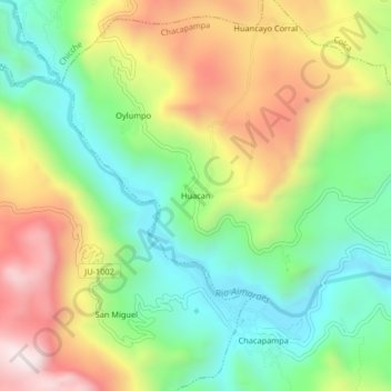
Name: Huacan topographic map, elevation, terrain.
Location: Huacan, Chacapampa, Huancayo, Junín, Perú (-12.35047 -75.27445 -12.31047 -75.23445)
Average elevation: 3,608 m
Minimum elevation: 3,313 m
Maximum elevation: 4,028 m
Thank you for supporting this site ❤️
Make a donation
Make a donation
Gear up for your next adventure:
As an Amazon Associate, this site earns from qualifying purchases at no extra cost to you.