
Thank you for supporting this site ❤️
Make a donation
Make a donation
Gear up for your next adventure:
As an Amazon Associate, this site earns from qualifying purchases at no extra cost to you.
Quimbaya topographic map
Click on the map to display elevation.
Thank you for supporting this site ❤️
Make a donation
Make a donation
Gear up for your next adventure:
As an Amazon Associate, this site earns from qualifying purchases at no extra cost to you.
About this map
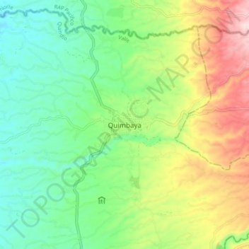
Name: Quimbaya topographic map, elevation, terrain.
Location: Quimbaya, Valle, Quindío, RAP Eje Cafetero, Colombia (4.58312 -75.80373 4.66312 -75.72373)
Average elevation: 1,306 m
Minimum elevation: 1,171 m
Maximum elevation: 1,550 m
Thank you for supporting this site ❤️
Make a donation
Make a donation
Gear up for your next adventure:
As an Amazon Associate, this site earns from qualifying purchases at no extra cost to you.