
Make a donation
Gear up for your next adventure:
As an Amazon Associate, this site earns from qualifying purchases at no extra cost to you.
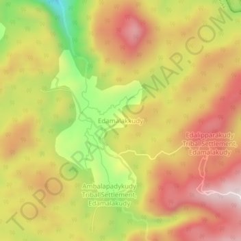
Edamalakkudy topographic map
Click on the map to display elevation.
Make a donation
Gear up for your next adventure:
As an Amazon Associate, this site earns from qualifying purchases at no extra cost to you.
Edamalakkudy
Edamalakudy is located at an elevation of 1100–1700 metres, 22 km north-west of Pettimudi, a village about 4 km west of the Anamudi, the tallest mountain peak in South India on the border of Ernakulam district and Idukki district. Pettimudi was hit by a landslide in 2018 and the debris have not been cleared. Pettimudi is not very remote, but is still not easy to reach as the path is hilly and fog is common and often intense, passing through the Eravikulam National Park, 16 km from Munnar by road and 18 km from Aanakkulam by walking through thick forests. Edamalakkudy is located in a large and mostly remote forest area between Malakkappara and Marayoor in the Anamalais, mainly spread over Ernakulam district, Idukki district, and a part of Thrissur district, which contains the Idamalayar Reserve Forest, covering a large area to the north, west and south of the Edamalayar Dam. The Idamalayar Reserve Forest covers various other tribal villages, spread over parts of eastern Ernakulam district, including Kappayam and Kaserapara. The western parts of the Edamalakkudy gram panchayat, such as Mulakutharakudy are also part of the Idamalayar Reserve Forest, while the rest comes under the Mankulam Forest Division of Kuttampuzha gram panchayat. The forests are surrounded to the south by a range of high-altitude grasslands, which include the village of Pettimudi and the highest peak in South India, the Anamudi. To the south-west is the Idamalayar-Pooyamkutty Valley, and various settlements including Pooyamkutty and Kuttampuzha, as well as Aanakkulam. Edamalakkudy is on this border, Valparai being on the Tamil Nadu side. While the area in Kerala consists of thick and remote forests, the Tamil Nadu area has mostly been deforested for tea plantations. Edamalakkudy was initially not very remote, but the Great flood of 99 which occurred in July 1924 destroyed the old Aluva-Munnar road making it hard to reach. The principal way of reaching Edamalakkudy was via Kuttampuzha-Mankulam at the time. The road was rebuilt till Pooyamkutty. The route via Idamalayar forest was closed to the public in 1985 due to environmental concerns after the construction of the Idamalayar Dam. Therefore, the route via Eravikulam National Park, which is a tourist location, is preferred today.
Make a donation
Gear up for your next adventure:
As an Amazon Associate, this site earns from qualifying purchases at no extra cost to you.
About this map
Name: Edamalakkudy topographic map, elevation, terrain.
Location: Edamalakkudy, Kothamangalam, Idukki, Kerala, India (10.18241 76.94326 10.22241 76.98326)
Average elevation: 1,095 m
Minimum elevation: 717 m
Maximum elevation: 1,376 m
Make a donation
Gear up for your next adventure:
As an Amazon Associate, this site earns from qualifying purchases at no extra cost to you.
Other topographic maps
Click on a map to view its topography, its elevation and its terrain.