
Make a donation
Gear up for your next adventure:
As an Amazon Associate, this site earns from qualifying purchases at no extra cost to you.
Selinsgrove topographic map
Click on the map to display elevation.
Make a donation
Gear up for your next adventure:
As an Amazon Associate, this site earns from qualifying purchases at no extra cost to you.
About this map
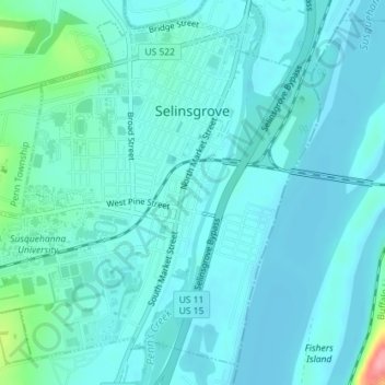
Name: Selinsgrove topographic map, elevation, terrain.
Location: Selinsgrove, Snyder County, Pennsylvania, United States (40.78838 -76.88097 40.81253 -76.84885)
Average elevation: 138 m
Minimum elevation: 123 m
Maximum elevation: 234 m
Make a donation
Gear up for your next adventure:
As an Amazon Associate, this site earns from qualifying purchases at no extra cost to you.
Other topographic maps
Click on a map to view its topography, its elevation and its terrain.
Faylor Lake
United States > Pennsylvania > Snyder County > Spring Township > Beaver Springs
Average elevation: 197 m
Faylor Lake
United States > Pennsylvania > Snyder County > Spring Township > Beaver Springs
Average elevation: 197 m