
Make a donation
Gear up for your next adventure:
As an Amazon Associate, this site earns from qualifying purchases at no extra cost to you.
Dedenborn topographic map
Click on the map to display elevation.
Make a donation
Gear up for your next adventure:
As an Amazon Associate, this site earns from qualifying purchases at no extra cost to you.
About this map
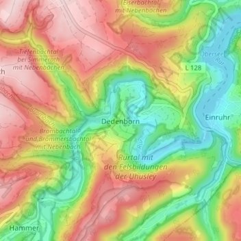
Name: Dedenborn topographic map, elevation, terrain.
Average elevation: 410 m
Minimum elevation: 280 m
Maximum elevation: 546 m
Make a donation
Gear up for your next adventure:
As an Amazon Associate, this site earns from qualifying purchases at no extra cost to you.
Other topographic maps
Click on a map to view its topography, its elevation and its terrain.
Rursee
Deutschland > Nordrhein-Westfalen > Städteregion Aachen > Simmerath > Woffelsbach
Die aus der Rurtalsperre Schwammenauel und dem Rurstausee bestehende Stauanlage befindet sich im Norden der Eifel (siehe Rureifel), nordwestlich und westlich des Kermeters, nordöstlich des Monschauer Heckenlandes und ostsüdöstlich des Höhenzuges Buhlert zwischen der Gemeinde Simmerath in der Städteregion…
Average elevation: 362 m
Westwall
Deutschland > Nordrhein-Westfalen > Städteregion Aachen > Simmerath > Bickerath
Average elevation: 533 m
Westwall
Deutschland > Nordrhein-Westfalen > Städteregion Aachen > Simmerath > Bickerath
Average elevation: 532 m
52152
Deutschland > Nordrhein-Westfalen > Städteregion Aachen > Simmerath > Kesternich
Average elevation: 472 m
Make a donation
Gear up for your next adventure:
As an Amazon Associate, this site earns from qualifying purchases at no extra cost to you.
Brombach
Deutschland > Nordrhein-Westfalen > Städteregion Aachen > Simmerath > Huppenbroich
Average elevation: 494 m
Rursee
Deutschland > Nordrhein-Westfalen > Städteregion Aachen > Simmerath > Woffelsbach
Average elevation: 362 m