
Make a donation
Gear up for your next adventure:
As an Amazon Associate, this site earns from qualifying purchases at no extra cost to you.
Les Chevailles topographic map
Click on the map to display elevation.
Make a donation
Gear up for your next adventure:
As an Amazon Associate, this site earns from qualifying purchases at no extra cost to you.
About this map
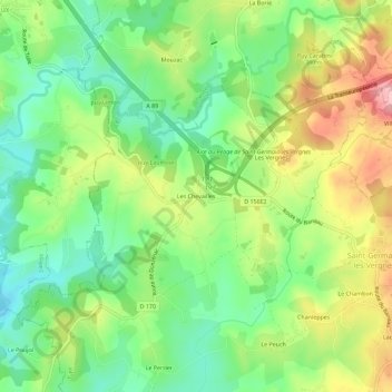
Name: Les Chevailles topographic map, elevation, terrain.
Average elevation: 343 m
Minimum elevation: 275 m
Maximum elevation: 445 m
Make a donation
Gear up for your next adventure:
As an Amazon Associate, this site earns from qualifying purchases at no extra cost to you.
Other topographic maps
Click on a map to view its topography, its elevation and its terrain.
Le Maumont Noir
France > Nouvelle-Aquitaine > Corrèze > Saint-Germain-les-Vergnes
Le Maumont Noir prend sa source sur la commune de Saint-Mexant à près de 410 mètres d'altitude, plus de deux kilomètres à l'ouest du bourg, au sud-est du lieu-dit Villièras.
Average elevation: 342 m