
Hillsborough County topographic map
Interactive map
Click on the map to display elevation.
Hillsborough County
Hillsborough County, located in west-central Florida, features a predominantly flat terrain with gentle undulations. The county's landscape is characterized by low-lying coastal plains that rise gradually from the shores of Tampa Bay, with elevations typically ranging from 16 to 66 feet (5 to 20 meters) above sea level. The highest points in the vicinity reach approximately 164 feet (50 meters). This relatively flat topography is interspersed with numerous water bodies, including the expansive Tampa Bay to the west and the Hillsborough River that meanders through the area, contributing to its lush vegetation and diverse ecosystems. The surrounding areas often feature wetlands and marshlands, particularly as one moves toward the coast, creating a rich environment for both wildlife and recreational activities.
About this map
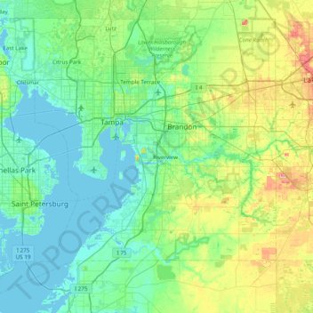
Name: Hillsborough County topographic map, elevation, terrain.
Location: Hillsborough County, Florida, United States (27.57055 -82.82367 28.17338 -82.05401)
Average elevation: 20 m
Minimum elevation: -2 m
Maximum elevation: 90 m
Other topographic maps
Click on a map to view its topography, its elevation and its terrain.
Britton Hill
United States > Florida > Walton County
Britton Hill is the highest natural point in the state of Florida, United States, with a summit elevation of 345 feet (105 meters) above mean sea level. Britton Hill is the lowest state highpoint in the United States, 103 feet (31 m) lower than the next lowest highpoint, Ebright Azimuth in Delaware, and far…
Average elevation: 93 m