
Make a donation
Gear up for your next adventure:
As an Amazon Associate, this site earns from qualifying purchases at no extra cost to you.
Copley topographic map
Click on the map to display elevation.
Make a donation
Gear up for your next adventure:
As an Amazon Associate, this site earns from qualifying purchases at no extra cost to you.
Copley
Copley has its own weather station run by the Met Office and Environment Agency. Because of its elevation above sea-level, around the 1,000 ft contour, and position in the north-east, this station is often one of the coldest in England with high incidences of ground frosts and snowfalls. Copley is in a relatively dry and sunny rain-shadow area in the shelter of the higher Pennines to the west. The same higher Pennines can create a local gusty effect if the wind blows from the west-south-west. This is called the Pennine Lee Wave and can appear suddenly and disappear just as quickly.
Make a donation
Gear up for your next adventure:
As an Amazon Associate, this site earns from qualifying purchases at no extra cost to you.
About this map
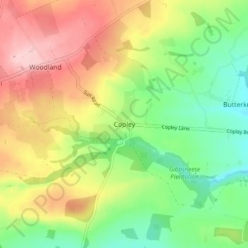
Name: Copley topographic map, elevation, terrain.
Average elevation: 261 m
Minimum elevation: 183 m
Maximum elevation: 358 m
Make a donation
Gear up for your next adventure:
As an Amazon Associate, this site earns from qualifying purchases at no extra cost to you.