
Make a donation
Gear up for your next adventure:
As an Amazon Associate, this site earns from qualifying purchases at no extra cost to you.
Lakeville topographic map
Click on the map to display elevation.
Make a donation
Gear up for your next adventure:
As an Amazon Associate, this site earns from qualifying purchases at no extra cost to you.
About this map
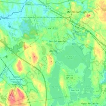
Name: Lakeville topographic map, elevation, terrain.
Location: Lakeville, Plymouth County, Massachusetts, United States (41.77890 -71.03657 41.90745 -70.89344)
Average elevation: 24 m
Minimum elevation: 3 m
Maximum elevation: 74 m
Make a donation
Gear up for your next adventure:
As an Amazon Associate, this site earns from qualifying purchases at no extra cost to you.
Other topographic maps
Click on a map to view its topography, its elevation and its terrain.
West Meadow
United States > Massachusetts > Plymouth County > West Bridgewater
Average elevation: 29 m
Make a donation
Gear up for your next adventure:
As an Amazon Associate, this site earns from qualifying purchases at no extra cost to you.
Make a donation
Gear up for your next adventure:
As an Amazon Associate, this site earns from qualifying purchases at no extra cost to you.
Kenberma
United States > Massachusetts > Plymouth County > Hull > Nantasket Beach
Average elevation: 2 m
Make a donation
Gear up for your next adventure:
As an Amazon Associate, this site earns from qualifying purchases at no extra cost to you.
Manomet Heights
United States > Massachusetts > Plymouth County > Plymouth > Manomet
Average elevation: 10 m
Marshfield Center
United States > Massachusetts > Plymouth County > Marshfield
Average elevation: 34 m
Mill Pond
United States > Massachusetts > Plymouth County > Duxbury > Miles Standish Park
Average elevation: 20 m
Make a donation
Gear up for your next adventure:
As an Amazon Associate, this site earns from qualifying purchases at no extra cost to you.
Eldon B. Kieth Field
United States > Massachusetts > Plymouth County > Brockton
Average elevation: 40 m
Fresh Pond
United States > Massachusetts > Plymouth County > Plymouth > Cedar Bushes
Average elevation: 14 m
Make a donation
Gear up for your next adventure:
As an Amazon Associate, this site earns from qualifying purchases at no extra cost to you.
Arthur Thurbur Land
United States > Massachusetts > Plymouth County > Duxbury > Baileys Corner
Average elevation: 18 m
Make a donation
Gear up for your next adventure:
As an Amazon Associate, this site earns from qualifying purchases at no extra cost to you.
Scotland Estates
United States > Massachusetts > Plymouth County > Bridgewater
Average elevation: 28 m
Make a donation
Gear up for your next adventure:
As an Amazon Associate, this site earns from qualifying purchases at no extra cost to you.
Peddocks Island
United States > Massachusetts > Plymouth County > Hull > Fort Andrews
Average elevation: 1 m
Great Herring Pond
United States > Massachusetts > Plymouth County > Plymouth > Cedarville
Average elevation: 24 m
Make a donation
Gear up for your next adventure:
As an Amazon Associate, this site earns from qualifying purchases at no extra cost to you.
Make a donation
Gear up for your next adventure:
As an Amazon Associate, this site earns from qualifying purchases at no extra cost to you.
Make a donation
Gear up for your next adventure:
As an Amazon Associate, this site earns from qualifying purchases at no extra cost to you.
Make a donation
Gear up for your next adventure:
As an Amazon Associate, this site earns from qualifying purchases at no extra cost to you.
Green Harbor River
United States > Massachusetts > Plymouth County > Marshfield > Green Harbor
Average elevation: 2 m
Kent Park
United States > Massachusetts > Plymouth County > Marshfield > Kent Park
Average elevation: 13 m
Cranberry Village
United States > Massachusetts > Plymouth County > Carver > Cranberry Village
Average elevation: 30 m
Make a donation
Gear up for your next adventure:
As an Amazon Associate, this site earns from qualifying purchases at no extra cost to you.
Indian Heights
United States > Massachusetts > Plymouth County > Wareham > Indian Heights
Average elevation: 8 m
Marshfield Hills
United States > Massachusetts > Plymouth County > Marshfield > Marshfield Hills
Average elevation: 29 m
Make a donation
Gear up for your next adventure:
As an Amazon Associate, this site earns from qualifying purchases at no extra cost to you.