
Cordemois topographic map
Interactive map
Click on the map to display elevation.
About this map
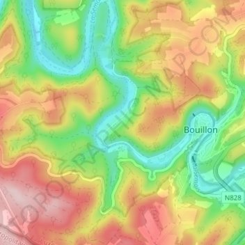
Name: Cordemois topographic map, elevation, terrain.
Average elevation: 312 m
Minimum elevation: 197 m
Maximum elevation: 443 m
Other topographic maps
Click on a map to view its topography, its elevation and its terrain.
Château des Amerois
Belgique > Luxembourg > Neufchâteau > Bouillon
Château des Amerois, Les Amerois, Bouillon, Neufchâteau, Luxembourg, Wallonie, 6830, Belgique
Average elevation: 401 m
Frahan
Belgique > Luxembourg > Neufchâteau > Bouillon
Frahan, Rochehaut, Bouillon, Neufchâteau, Luxembourg, Wallonie, 6838, Belgique
Average elevation: 291 m
Dohan
Belgique > Luxembourg > Neufchâteau > Bouillon
Dohan, Bouillon, Neufchâteau, Luxembourg, Wallonie, Belgique
Average elevation: 284 m
Botassart
Belgique > Luxembourg > Neufchâteau > Bouillon > Ucimont
Botassart, Ucimont, Bouillon, Neufchâteau, Luxembourg, Wallonie, 6833, Belgique
Average elevation: 319 m
Rochehaut
Belgique > Luxembourg > Neufchâteau > Bouillon
Rochehaut, Bouillon, Neufchâteau, Luxembourg, Wallonie, Belgique
Average elevation: 298 m
Corbion
Belgique > Luxembourg > Neufchâteau > Bouillon
Corbion, Bouillon, Neufchâteau, Luxembourg, Wallonie, 6838, Belgique
Average elevation: 344 m
Bouillon
Belgique > Luxembourg > Neufchâteau > Bouillon
Bouillon, Neufchâteau, Luxembourg, Wallonie, 6830, Belgique
Average elevation: 338 m
Sensenruth
Belgique > Luxembourg > Neufchâteau > Bouillon
Sensenruth, Bouillon, Neufchâteau, Luxembourg, Wallonie, 6832, Belgique
Average elevation: 359 m
Poupehan
Belgique > Luxembourg > Neufchâteau > Bouillon
Poupehan, Bouillon, Neufchâteau, Luxembourg, Wallonie, Belgique
Average elevation: 270 m