
Make a donation
Gear up for your next adventure:
As an Amazon Associate, this site earns from qualifying purchases at no extra cost to you.
Neuenbeken topographic map
Click on the map to display elevation.
Make a donation
Gear up for your next adventure:
As an Amazon Associate, this site earns from qualifying purchases at no extra cost to you.
Neuenbeken
Neuenbeken liegt nordöstlich der Paderborner Kernstadt bei 51° 44′ Nord und 8° 51′ Ost im Norden der Paderborner Hochfläche am Westrand des Eggegebirges auf einer Höhe von 170 m ü. NN. Naturräumlich gehört Neuenbeken mit Benhausen zu den Borchener Platten der Paderborner Hochfläche im oberen Weserbergland. Im Osten grenzt dieser Naturraum an die Marienloher Schotterebene der Hellwegbörden in der Westfälischen Bucht.
Make a donation
Gear up for your next adventure:
As an Amazon Associate, this site earns from qualifying purchases at no extra cost to you.
About this map
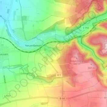
Name: Neuenbeken topographic map, elevation, terrain.
Average elevation: 249 m
Minimum elevation: 146 m
Maximum elevation: 369 m
Make a donation
Gear up for your next adventure:
As an Amazon Associate, this site earns from qualifying purchases at no extra cost to you.
Other topographic maps
Click on a map to view its topography, its elevation and its terrain.
Habichtsee
Deutschland > Nordrhein-Westfalen > Kreis Paderborn > Paderborn > Sennelager
Average elevation: 112 m
Barkhausen
Deutschland > Nordrhein-Westfalen > Kreis Paderborn > Paderborn > Wewer
Average elevation: 139 m
Make a donation
Gear up for your next adventure:
As an Amazon Associate, this site earns from qualifying purchases at no extra cost to you.
Tallesee Mittelsee
Deutschland > Nordrhein-Westfalen > Kreis Paderborn > Paderborn
Average elevation: 118 m
Nesthauser See
Deutschland > Nordrhein-Westfalen > Kreis Paderborn > Paderborn > Sande
Average elevation: 101 m