
Patah topographic map
Interactive map
Click on the map to display elevation.
About this map
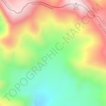
Name: Patah topographic map, elevation, terrain.
Location: Patah, Kampung Melayu, Bengkulu, Indonesien (-4.27005 103.29995 -4.26995 103.30005)
Average elevation: 2,513 m
Minimum elevation: 2,200 m
Maximum elevation: 2,827 m
Other topographic maps
Click on a map to view its topography, its elevation and its terrain.
Tais
Indonesien > Bengkulu > Seluma
Tais, Seluma, Bengkulu, Sumatra, Indonesien
Average elevation: 53 m
Belirang-Beriti
Belirang-Beriti, Muara Bangkahulu, Bengkulu, Indonesien
Average elevation: 1,530 m