
Make a donation
Gear up for your next adventure:
As an Amazon Associate, this site earns from qualifying purchases at no extra cost to you.
Saaleck topographic map
Click on the map to display elevation.
Make a donation
Gear up for your next adventure:
As an Amazon Associate, this site earns from qualifying purchases at no extra cost to you.
About this map
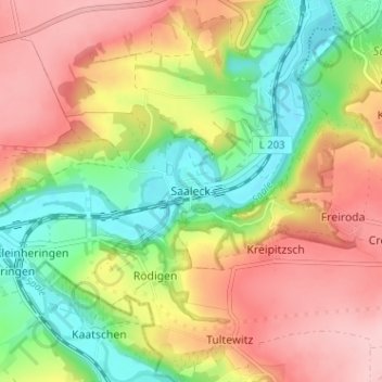
Name: Saaleck topographic map, elevation, terrain.
Average elevation: 194 m
Minimum elevation: 110 m
Maximum elevation: 279 m
Make a donation
Gear up for your next adventure:
As an Amazon Associate, this site earns from qualifying purchases at no extra cost to you.
Other topographic maps
Click on a map to view its topography, its elevation and its terrain.
Prießnitz
Deutschland > Sachsen-Anhalt > Burgenlandkreis > Naumburg (Saale)
Prießnitz liegt zwischen Jena und Naumburg (Saale) auf einem erhöhten überlössten Ackerbaustandort südlich der Saaleanhöhen bei Naumburg.
Average elevation: 251 m
Saale-Ilm-Platten bei Bad Kösen
Deutschland > Sachsen-Anhalt > Burgenlandkreis > Naumburg (Saale) > Schulpforte
Bergbaufolgelandschaft Kayna-Süd | Forst Bibra | Göttersitz | Grubengelände Nordfeld Jaucha | Halbberge bei Mertendorf | Heideteiche bei Osterfeld | Hirschrodaer Graben | Neue Göhle | Saale-Ilm-Platten bei Bad Kösen | Saaleaue bei Goseck | Schmoner Busch, Spielberger Höhe und Elsloch | Steinklöbe | Tote…
Average elevation: 207 m