
Thank you for supporting this site ❤️
Make a donation
Make a donation
Gear up for your next adventure:
As an Amazon Associate, this site earns from qualifying purchases at no extra cost to you.
Macael topographic map
Click on the map to display elevation.
Thank you for supporting this site ❤️
Make a donation
Make a donation
Gear up for your next adventure:
As an Amazon Associate, this site earns from qualifying purchases at no extra cost to you.
About this map
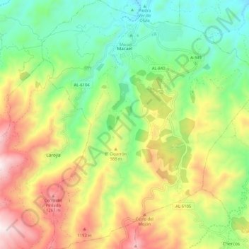
Name: Macael topographic map, elevation, terrain.
Location: Macael, Valle del Almanzora, Almeria, Andalusia, 04867, Spain (37.26489 -2.33683 37.34685 -2.24314)
Average elevation: 839 m
Minimum elevation: 455 m
Maximum elevation: 1,407 m
Thank you for supporting this site ❤️
Make a donation
Make a donation
Gear up for your next adventure:
As an Amazon Associate, this site earns from qualifying purchases at no extra cost to you.