
Make a donation
Gear up for your next adventure:
As an Amazon Associate, this site earns from qualifying purchases at no extra cost to you.
Hallstatt topographic map
Click on the map to display elevation.
Make a donation
Gear up for your next adventure:
As an Amazon Associate, this site earns from qualifying purchases at no extra cost to you.
Hallstatt
The Hallstatt salt mine is the world's oldest working salt mine. The mine is located within the Upper Permian to Lower Triassic Haselgebirge Formation of the Northern Limestone Alps. The Hallstatt salt mine comprises 21 levels and several smaller shafts ranging from 514 metres (1,686 ft) above sea level (Erbstollen level) to an elevation of around 1,267 m (4,157 ft) (Erzherzog Matthias Schurf level).
Make a donation
Gear up for your next adventure:
As an Amazon Associate, this site earns from qualifying purchases at no extra cost to you.
About this map
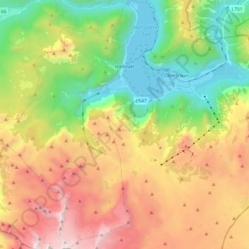
Name: Hallstatt topographic map, elevation, terrain.
Location: Hallstatt, Bezirk Gmunden, Upper Austria, 4830, Austria (47.47500 13.55157 47.59373 13.67212)
Average elevation: 1,514 m
Minimum elevation: 501 m
Maximum elevation: 2,903 m
Make a donation
Gear up for your next adventure:
As an Amazon Associate, this site earns from qualifying purchases at no extra cost to you.
Other topographic maps
Click on a map to view its topography, its elevation and its terrain.
Hoher Dachstein
Austria > Upper Austria > Bezirk Gmunden > Gosau
The Dachstein massif covers an area of around 600 square kilometres (230 sq mi) with dozens of peaks above 2,500 m, the highest of which are in the southern and southwestern areas. The main summit of the Hoher Dachstein is at an elevation of 2,997 metres (9,833 ft). Seen from the north, the Dachstein massif is…
Average elevation: 2,341 m
Make a donation
Gear up for your next adventure:
As an Amazon Associate, this site earns from qualifying purchases at no extra cost to you.
Predigstuhl
Austria > Upper Austria > Bezirk Gmunden > Bad Goisern am Hallstättersee
Average elevation: 921 m
Bad Goisern
Austria > Upper Austria > Bezirk Gmunden > Bad Goisern am Hallstättersee > Bad Goisern
Average elevation: 644 m
Make a donation
Gear up for your next adventure:
As an Amazon Associate, this site earns from qualifying purchases at no extra cost to you.
Make a donation
Gear up for your next adventure:
As an Amazon Associate, this site earns from qualifying purchases at no extra cost to you.