
New Canaan topographic map
Interactive map
Click on the map to display elevation.
About this map
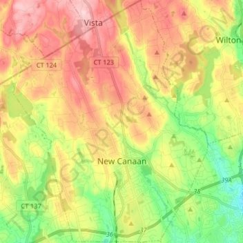
Name: New Canaan topographic map, elevation, terrain.
Average elevation: 102 m
Minimum elevation: 10 m
Maximum elevation: 197 m
Other topographic maps
Click on a map to view its topography, its elevation and its terrain.
Tokeneke
United States > Connecticut > Western Connecticut Planning Region > Darien
Average elevation: 14 m
Ponus
United States > Connecticut > Western Connecticut Planning Region > New Canaan
Average elevation: 77 m