Geolocate

Ferns topographic map

Interactive map

Click on the map to display elevation.

Ferns

The 19th-century population peaked in 1851, but never reached the levels of medieval times. Lewis's Topography of 1834 claimed the town "consists chiefly of one irregular street, and contains 106 houses indifferently built, retaining no trace of its ancient importance". The Abbey, St.Peter's Church (Catholic and Anglican), and the remainder of the great cathedral are regarded as historic, holy places, and are still regarded as churches. This includes the abbey, which has the title of an abbey church.

Wikipedia (CC-BY-SA 3.0)

About this map

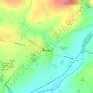
Name: Ferns topographic map, elevation, terrain.

Location: Ferns, The Municipal District of Enniscorthy, County Wexford, Leinster, Ireland (52.58372 -6.51022 52.59804 -6.48838)

Average elevation: 53 m

Minimum elevation: 17 m

Maximum elevation: 107 m

County Wexford trails, hiking, mountain biking, running and outdoor activities

Other topographic maps

Click on a map to view its topography, its elevation and its terrain.

Ballindaggan

Ireland > County Wexford

Average elevation: 123 m

Monaseed

Ireland > County Wexford

Average elevation: 174 m

Kiltealy

Ireland > County Wexford

Average elevation: 163 m

Mount Leinster

Ireland > County Wexford

Average elevation: 503 m

Castlebridge

Ireland > County Wexford

Average elevation: 18 m

Ballyhealy Castle

Ireland > County Wexford

Average elevation: 7 m

Forth Mountain

Ireland > County Wexford

Average elevation: 154 m

Slaney

Ireland > County Wexford

Average elevation: 50 m

Killinick

Ireland > County Wexford

Average elevation: 12 m

Mayglass

Ireland > County Wexford

Average elevation: 18 m

Ramsgrange

Ireland > County Wexford

Average elevation: 51 m

Templeshanbo

Ireland > County Wexford

Average elevation: 126 m

Enniscorthy

Ireland > County Wexford > Enniscorthy

Average elevation: 44 m

Blackwater

Ireland > County Wexford > Blackwater

Average elevation: 38 m

Tara Hill

Ireland > County Wexford

Average elevation: 77 m

Fethard

Ireland > County Wexford > Fethard

Average elevation: 12 m

Hook Head

Ireland > County Wexford

Average elevation: 2 m

Croghan Kinsella

Ireland > County Wexford

Average elevation: 399 m

Ballyedmond

Ireland > County Wexford

Average elevation: 74 m

Baginbun Head

Ireland > County Wexford

Average elevation: 4 m

Greenore Point

Ireland > County Wexford

Average elevation: 3 m

Blackwater Head

Ireland > County Wexford

Average elevation: 10 m

Cahore

Ireland > County Wexford > Cahore

Average elevation: 8 m

Great Saltee

Ireland > County Wexford

Average elevation: 2 m

Kilmore

Ireland > County Wexford

Average elevation: 10 m

Carrick

Ireland > County Wexford > Carrick

Average elevation: 27 m

Ballygarrett

Ireland > County Wexford > Ballygarrett

Average elevation: 23 m