
Glen Etive topographic map
Interactive map
Click on the map to display elevation.
About this map
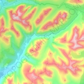
Name: Glen Etive topographic map, elevation, terrain.
Location: Glen Etive, Highland, Scotland, United Kingdom (56.56203 -5.07043 56.65180 -4.84400)
Average elevation: 477 m
Minimum elevation: 0 m
Maximum elevation: 1,137 m
Other topographic maps
Click on a map to view its topography, its elevation and its terrain.
Skye
United Kingdom > Scotland > Highland
Beyond Loch Snizort to the west of Trotternish is the Waternish peninsula, which ends in Ardmore Point's double rock arch. Duirinish peninsula is separated from Waternish by Loch Dunvegan, which contains the island of Isay. It is ringed by sea cliffs that reach 296 metres (971 feet) on the west at Waterstein…
Average elevation: 63 m
Ben Nevis
United Kingdom > Scotland > Highland
Ben Nevis has a highland (alpine) maritime (oceanic) polar climate (ET climate in the Köppen classification). Ben Nevis's elevation, maritime location and topography frequently lead to cool and cloudy weather conditions, which can pose a danger to ill-equipped walkers. According to the observations carried…
Average elevation: 912 m
Fort William
United Kingdom > Scotland > Highland
Fort William has an oceanic climate (Cfb) with moderate, but generally cool, temperatures and abundant precipitation. In the towns immediate vicinity, there are significant variations in elevation, which leads to some uninhabited areas near the town having a subpolar oceanic climate (Cfc), or, at the absolute…
Average elevation: 122 m
Skye
United Kingdom > Scotland > Highland
Beyond Loch Snizort to the west of Trotternish is the Waternish peninsula, which ends in Ardmore Point's double rock arch. Duirinish peninsula is separated from Waternish by Loch Dunvegan, which contains the island of Isay. It is ringed by sea cliffs that reach 296 metres (971 feet) on the west at Waterstein…
Average elevation: 63 m
Ben Nevis
United Kingdom > Scotland > Highland
Ben Nevis has a highland tundra climate (ET in the Köppen classification). Ben Nevis's elevation, maritime location and topography frequently lead to cool and cloudy weather conditions, which can pose a danger to ill-equipped walkers. According to the observations carried out at the summit observatory from…
Average elevation: 912 m
Cairn Gorm
United Kingdom > Scotland > Highland
Cairn Gorm (Scottish Gaelic: An Càrn Gorm) is a mountain in the Scottish Highlands. It is part of the Cairngorms range and wider Grampian Mountains. With a summit elevation of 1,245 m (4,085 ft) above sea level, Cairn Gorm is classed as a Munro and is the sixth-highest mountain in the British Isles. The high,…
Average elevation: 989 m
Kinlochleven
United Kingdom > Scotland > Highland
Work on the dam and water supply system began in 1905 and was completed in 1907. The hydro-electric scheme was constructed for the British Aluminium Company and was designed by engineer brothers Patrick and Charles Meik. The chief assistant resident engineer on the project was a young William Halcrow. The…
Average elevation: 306 m
Ardnamurchan
United Kingdom > Scotland > Highland
The north western corner of Ardnamurchan consists of a lopolith (previously interpreted as a ring dyke) that has been exposed at the surface. Evidence for such a structure can be identified from the phenocrysts in the rock exposures around the area of interest which show plagioclase crystals aligned towards…
Average elevation: 73 m
Aonach Beag
United Kingdom > Scotland > Highland
Aonach Beag is linked to its close neighbour to the north, Aonach Mòr, by a high saddle or bealach. The name Aonach Beag (small ridge) might imply that this mountain is smaller than Aonach Mòr (big ridge). However, Aonach Beag is higher; the names refer to the relative bulk of the two mountains rather than…
Average elevation: 825 m
Aonach Mòr
United Kingdom > Scotland > Highland
Aonach Mòr is a mountain in the Scottish Highlands. It is located about two miles (three kilometres) northeast of Ben Nevis on the south side of Glen Spean, near Fort William. The mountain has a summit elevation of 4,006 ft (1,221 m) and is classified as a Munro.
Average elevation: 898 m
Kinlochleven
United Kingdom > Scotland > Highland
Work on the dam and water supply system began in 1905 and was completed in 1907. The hydro-electric scheme was constructed for the British Aluminium Company and was designed by engineer brothers Patrick and Charles Meik. The chief assistant resident engineer on the project was a young William Halcrow. The…
Average elevation: 306 m
Scottish Highlands
United Kingdom > Scotland > Highland
The entire region was covered by ice sheets during the Pleistocene ice ages, save perhaps for a few nunataks. The complex geomorphology includes incised valleys and lochs carved by the action of mountain streams and ice, and a topography of irregularly distributed mountains whose summits have similar heights…
Average elevation: 907 m
Fort William
United Kingdom > Scotland > Highland
Fort William has an oceanic climate (Cfb) with moderate, but generally cool, temperatures and abundant precipitation. In the towns immediate vicinity, there are significant variations in elevation, which leads to some uninhabited areas near the town having a subpolar oceanic climate (Cfc), or, at the absolute…
Average elevation: 122 m
Skye
United Kingdom > Scotland > Highland
Beyond Loch Snizort to the west of Trotternish is the Waternish peninsula, which ends in Ardmore Point's double rock arch. Duirinish peninsula is separated from Waternish by Loch Dunvegan, which contains the island of Isay. It is ringed by sea cliffs that reach 296 metres (971 feet) on the west at Waterstein…
Average elevation: 63 m
Prince Charles's Stone
United Kingdom > Scotland > Highland > Tomatin > Raigbeg
Average elevation: 317 m
Ben Bhraggie
United Kingdom > Scotland > Highland
Ben Bhraggie (Scottish Gaelic: Beinn a' Bhragaidh) is a hill in Scotland which rises to an elevation of 397 metres (1,302 ft) above sea level. The hill dominates the skyline above the village of Golspie and is visible from many parts of east Sutherland. The 100-foot-tall (30-metre) statue which is perched on…
Average elevation: 216 m
Cairn Gorm
United Kingdom > Scotland > Highland
Cairn Gorm (Scottish Gaelic: An Càrn Gorm) is a mountain in the Scottish Highlands. It is part of the Cairngorms range and wider Grampian Mountains. With a summit elevation of 1,244.8 m (4,084 ft) above sea level, Cairn Gorm is classed as a Munro and is the sixth-highest mountain in the British Isles. The…
Average elevation: 989 m