
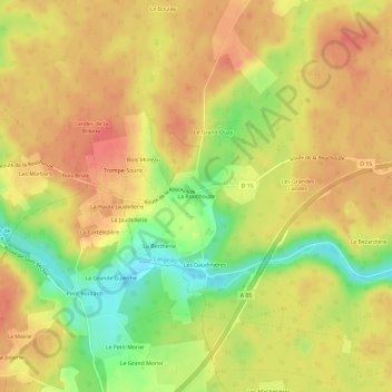
La Rouchouze topographic map
Interactive map
Click on the map to display elevation.
About this map
Name: La Rouchouze topographic map, elevation, terrain.
Average elevation: 86 m
Minimum elevation: 49 m
Maximum elevation: 108 m
Other topographic maps
Click on a map to view its topography, its elevation and its terrain.
La Terre de la Ceuille Roulée
France > Centre-Val de Loire > Indre-et-Loire > Langeais
La Terre de la Ceuille Roulée, Les Essards, Langeais, Chinon, Indre-et-Loire, Centre-Val de Loire, France métropolitaine, 37130, France
Average elevation: 89 m
Langeais
France > Centre-Val de Loire > Indre-et-Loire > Langeais
Langeais, Chinon, Indre-et-Loire, Centre-Val de Loire, France métropolitaine, 37130, France
Average elevation: 82 m
Bresne
France > Centre-Val de Loire > Indre-et-Loire > Langeais
Bresne, Langeais, Chinon, Indre-et-Loire, Centre-Val de Loire, France métropolitaine, 37130, France
Average elevation: 83 m
Fougeray
France > Centre-Val de Loire > Indre-et-Loire > Langeais
Fougeray, Langeais, Chinon, Indre-et-Loire, Centre-Val de Loire, France métropolitaine, 37130, France
Average elevation: 62 m
Marais
France > Centre-Val de Loire > Indre-et-Loire > Langeais
Marais, Les Essards, Langeais, Chinon, Indre-et-Loire, Centre-Val de Loire, France métropolitaine, 37130, France
Average elevation: 89 m
La Mulotière
France > Centre-Val de Loire > Indre-et-Loire > Langeais > La Mulotière
La Mulotière, Langeais, Chinon, Indre-et-Loire, Centre-Val de Loire, France métropolitaine, 37130, France
Average elevation: 62 m
L'Aunay Briquart
France > Centre-Val de Loire > Indre-et-Loire > Langeais > L'Aunay Briquart
L'Aunay Briquart, Langeais, Chinon, Indre-et-Loire, Centre-Val de Loire, France métropolitaine, 37130, France
Average elevation: 87 m
Les Culevaux
France > Centre-Val de Loire > Indre-et-Loire > Langeais
Les Culevaux, Langeais, Chinon, Indre-et-Loire, Centre-Val de Loire, France métropolitaine, 37130, France
Average elevation: 68 m
Les Robichonnes
France > Centre-Val de Loire > Indre-et-Loire > Langeais
Les Robichonnes, Langeais, Chinon, Indre-et-Loire, Centre-Val de Loire, France métropolitaine, 37130, France
Average elevation: 93 m
Vernou
France > Centre-Val de Loire > Indre-et-Loire > Langeais > Vernou
Vernou, Langeais, Chinon, Indre-et-Loire, Centre-Val de Loire, France métropolitaine, 37130, France
Average elevation: 95 m