
Thank you for supporting this site ❤️
Make a donation
Make a donation
Gear up for your next adventure:
As an Amazon Associate, this site earns from qualifying purchases at no extra cost to you.
Chaullagon topographic map
Click on the map to display elevation.
Thank you for supporting this site ❤️
Make a donation
Make a donation
Gear up for your next adventure:
As an Amazon Associate, this site earns from qualifying purchases at no extra cost to you.
About this map
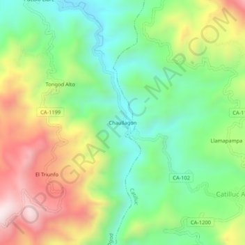
Name: Chaullagon topographic map, elevation, terrain.
Location: Chaullagon, Tongod, San Miguel, Cajamarca, Perú (-6.81001 -78.81744 -6.77001 -78.77744)
Average elevation: 2,880 m
Minimum elevation: 2,582 m
Maximum elevation: 3,338 m
Thank you for supporting this site ❤️
Make a donation
Make a donation
Gear up for your next adventure:
As an Amazon Associate, this site earns from qualifying purchases at no extra cost to you.