
Make a donation
Gear up for your next adventure:
As an Amazon Associate, this site earns from qualifying purchases at no extra cost to you.
Kandahar topographic map
Click on the map to display elevation.
Make a donation
Gear up for your next adventure:
As an Amazon Associate, this site earns from qualifying purchases at no extra cost to you.
Kandahar
Kandahar (English: /ˈkændəhɑːr/; Pashto: کندهار, romanized: kandahār; Dari: قندهار, romanized: qandahār) is a city in Afghanistan, located in the south of the country on the Arghandab River, at an elevation of 1,010 m (3,310 ft). It is Afghanistan's second largest city after Kabul, with a population of about 614,118. It is the capital of Kandahar Province and the centre of the larger cultural region called Loy Kandahar. Kandahar is the founding city and spiritual center of the Taliban. Despite the capital of Afghanistan being Kabul, where the government administration is based, Kandahar is the seat of power in Afghanistan as the supreme leader and his spiritual advisers are based there. Kandahar has therefore been called the de facto capital of Afghanistan, though the Taliban maintain Kabul is the capital.
Make a donation
Gear up for your next adventure:
As an Amazon Associate, this site earns from qualifying purchases at no extra cost to you.
About this map
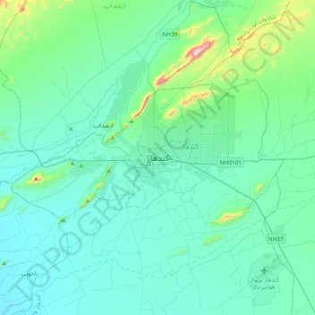
Name: Kandahar topographic map, elevation, terrain.
Location: Kandahar, Kandahar Province, 3801, Afghanistan (31.46057 65.55576 31.78057 65.87576)
Average elevation: 1,048 m
Minimum elevation: 940 m
Maximum elevation: 1,776 m
Make a donation
Gear up for your next adventure:
As an Amazon Associate, this site earns from qualifying purchases at no extra cost to you.