
Make a donation
Gear up for your next adventure:
As an Amazon Associate, this site earns from qualifying purchases at no extra cost to you.
Quepos topographic map
Click on the map to display elevation.
Make a donation
Gear up for your next adventure:
As an Amazon Associate, this site earns from qualifying purchases at no extra cost to you.
Quepos
Quepos has an area of 235.81 km² and an elevation of 5 metres.
Make a donation
Gear up for your next adventure:
As an Amazon Associate, this site earns from qualifying purchases at no extra cost to you.
About this map
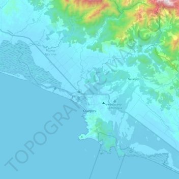
Name: Quepos topographic map, elevation, terrain.
Location: Quepos, Cantón Quepos, Puntarenas Province, 60601, Costa Rica (9.34452 -84.25419 9.57201 -84.02449)
Average elevation: 96 m
Minimum elevation: -1 m
Maximum elevation: 1,359 m
Make a donation
Gear up for your next adventure:
As an Amazon Associate, this site earns from qualifying purchases at no extra cost to you.
Other topographic maps
Click on a map to view its topography, its elevation and its terrain.