
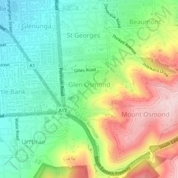
Glen Osmond topographic map
Interactive map
Click on the map to display elevation.
About this map
Name: Glen Osmond topographic map, elevation, terrain.
Average elevation: 196 m
Minimum elevation: 77 m
Maximum elevation: 388 m
Other topographic maps
Click on a map to view its topography, its elevation and its terrain.
Adelaide
Australia > South Australia > Adelaide
Adelaide, Adelaide City Council, South Australia, 5000, Australia
Average elevation: 148 m
Belair
Australia > South Australia > Adelaide
Belair, Adelaide, City of Mitcham, South Australia, 5052, Australia
Average elevation: 234 m
Hilton
Australia > South Australia > Adelaide
Hilton, Adelaide, City of West Torrens, South Australia, 5033, Australia
Average elevation: 19 m
Hallett Cove
Australia > South Australia > Adelaide
Hallett Cove, Adelaide, City of Marion, South Australia, 5158, Australia
Average elevation: 83 m
Lynton
Australia > South Australia > Adelaide
Lynton, Adelaide, City of Mitcham, South Australia, 5062, Australia
Average elevation: 163 m
Port Adelaide
Australia > South Australia > Adelaide
Port Adelaide, Adelaide, City of Port Adelaide Enfield, South Australia, 5015, Australia
Average elevation: 5 m
Blackwood
Australia > South Australia > Adelaide
Blackwood, Adelaide, City of Mitcham, South Australia, 5051, Australia
Average elevation: 232 m
Forestville
Australia > South Australia > Adelaide
Forestville, Adelaide, City of Unley, South Australia, 5035, Australia
Average elevation: 34 m
Mitchell Park
Australia > South Australia > Adelaide
Mitchell Park, Adelaide, City of Marion, South Australia, 5043, Australia
Average elevation: 38 m
Darlington
Australia > South Australia > Adelaide
Darlington, Adelaide, City of Marion, South Australia, 5047, Australia
Average elevation: 95 m
Uleybury
Australia > South Australia > Adelaide
Uleybury, Adelaide, City of Playford, South Australia, 5114, Australia
Average elevation: 183 m
Yatala Vale
Australia > South Australia > Adelaide
Yatala Vale, Adelaide, City of Tea Tree Gully, South Australia, 5126, Australia
Average elevation: 269 m
Dover Gardens
Australia > South Australia > Adelaide
Dover Gardens, Adelaide, City of Marion, South Australia, 5048, Australia
Average elevation: 41 m
Tennyson Beach
Australia > South Australia > Adelaide
Tennyson Beach, Tennyson, Adelaide, City of Charles Sturt, South Australia, 5022, Australia
Average elevation: 3 m
Munno Para Downs
Australia > South Australia > Adelaide
Munno Para Downs, Adelaide, City of Playford, South Australia, 5115, Australia
Average elevation: 40 m
Glenelg
Australia > South Australia > Adelaide
Glenelg, Adelaide, City of Holdfast Bay, South Australia, 5045, Australia
Average elevation: 6 m
Gilles Plains
Australia > South Australia > Adelaide
Gilles Plains, Adelaide, City of Port Adelaide Enfield, South Australia, 5086, Australia
Average elevation: 88 m
Unley Park
Australia > South Australia > Adelaide
Unley Park, Adelaide, City of Unley, South Australia, 5061, Australia
Average elevation: 55 m
Evanston Park
Australia > South Australia > Adelaide
Evanston Park, Adelaide, Town of Gawler, South Australia, 5116, Australia
Average elevation: 113 m
Tennyson
Australia > South Australia > Adelaide
Tennyson, Adelaide, City of Charles Sturt, South Australia, 5022, Australia, Tennyson Dunes
Average elevation: 4 m
St Marys
Australia > South Australia > Adelaide
St Marys, Adelaide, City of Mitcham, South Australia, 5042, Australia
Average elevation: 65 m
Blakeview
Australia > South Australia > Adelaide
Blakeview, Adelaide, City of Playford, South Australia, 5114, Australia
Average elevation: 87 m
Findon
Australia > South Australia > Adelaide
Findon, Adelaide, City of Charles Sturt, South Australia, 5023, Australia
Average elevation: 12 m
Bellevue Heights
Australia > South Australia > Adelaide
Bellevue Heights, Adelaide, City of Mitcham, South Australia, 5050, Australia
Average elevation: 147 m
Munno Para
Australia > South Australia > Adelaide
Munno Para, Adelaide, City of Playford, South Australia, 5115, Australia
Average elevation: 42 m
Clearview
Australia > South Australia > Adelaide
Clearview, Adelaide, City of Port Adelaide Enfield, South Australia, 5085, Australia
Average elevation: 52 m
Mawson Lakes
Australia > South Australia > Adelaide
Mawson Lakes, Adelaide, City of Salisbury, South Australia, 5095, Australia
Average elevation: 10 m
Craigburn Farm
Australia > South Australia > Adelaide
Craigburn Farm, Adelaide, City of Mitcham, South Australia, 5051, Australia
Average elevation: 209 m
Bibaringa
Australia > South Australia > Adelaide
Bibaringa, Adelaide, City of Playford, South Australia, 5118, Australia
Average elevation: 160 m
Leabrook
Australia > South Australia > Adelaide
Leabrook, Adelaide, City of Burnside, South Australia, 5068, Australia
Average elevation: 112 m
Golden Grove
Australia > South Australia > Adelaide
Golden Grove, Adelaide, City of Tea Tree Gully, South Australia, 5125, Australia
Average elevation: 215 m
Seacliff
Australia > South Australia > Adelaide
Seacliff, Adelaide, City of Holdfast Bay, South Australia, 5049, Australia
Average elevation: 36 m
Fullarton
Australia > South Australia > Adelaide
Fullarton, Adelaide, City of Unley, South Australia, 5063, Australia
Average elevation: 78 m
Henley Beach
Australia > South Australia > Adelaide
Henley Beach, Adelaide, City of Charles Sturt, South Australia, 5022, Australia
Average elevation: 6 m
Beaumont
Australia > South Australia > Adelaide
Beaumont, Adelaide, City of Burnside, South Australia, 5066, Australia
Average elevation: 196 m
Angle Vale
Australia > South Australia > Adelaide
Angle Vale, Adelaide, City of Playford, South Australia, 5117, Australia
Average elevation: 34 m
Bolivar
Australia > South Australia > Adelaide
Bolivar, Adelaide, City of Salisbury, South Australia, 5110, Australia
Average elevation: 6 m
Buckland Park
Australia > South Australia > Adelaide
Buckland Park, Adelaide, City of Playford, South Australia, 5120, Australia
Average elevation: 9 m
Tennyson
Australia > South Australia > Adelaide
Tennyson, Adelaide, City of Charles Sturt, South Australia, 5022, Australia
Average elevation: 4 m
Morialta Conservation Park
Australia > South Australia > Adelaide
Morialta Conservation Park, Cortlyne Road, Rostrevor, Adelaide, South Australia, 5073, Australia
Average elevation: 346 m
Seaforth Park
Australia > South Australia > Adelaide
Seaforth Park, Somerton Park, Adelaide, City of Holdfast Bay, South Australia, 5044, Australia
Average elevation: 7 m
Largs Bay
Australia > South Australia > Adelaide
Largs Bay, Adelaide, City of Port Adelaide Enfield, South Australia, 5016, Australia
Average elevation: 6 m
Trott Park
Australia > South Australia > Adelaide
Trott Park, Adelaide, City of Marion, South Australia, 5158, Australia
Average elevation: 147 m
Valley View
Australia > South Australia > Adelaide
Valley View, Adelaide, City of Salisbury, South Australia, 5093, Australia
Average elevation: 99 m
Hawthorndene
Australia > South Australia > Adelaide
Hawthorndene, Adelaide, City of Mitcham, South Australia, 5051, Australia
Average elevation: 264 m
O'Halloran Hill
Australia > South Australia > Adelaide
O'Halloran Hill, City of Marion, South Australia, 5158, Australia
Average elevation: 160 m
Munno Para West
Australia > South Australia > Adelaide
Munno Para West, Adelaide, City of Playford, South Australia, 5115, Australia
Average elevation: 35 m
Parkside
Australia > South Australia > Adelaide
Parkside, Adelaide, City of Unley, South Australia, 5063, Australia
Average elevation: 60 m
Elizabeth North
Australia > South Australia > Adelaide
Elizabeth North, Adelaide, City of Playford, South Australia, 5113, Australia
Average elevation: 48 m
Skye
Australia > South Australia > Adelaide
Skye, Adelaide, City of Burnside, South Australia, 5072, Australia
Average elevation: 277 m