
Make a donation
Gear up for your next adventure:
As an Amazon Associate, this site earns from qualifying purchases at no extra cost to you.
Conyngham topographic map
Click on the map to display elevation.
Make a donation
Gear up for your next adventure:
As an Amazon Associate, this site earns from qualifying purchases at no extra cost to you.
About this map
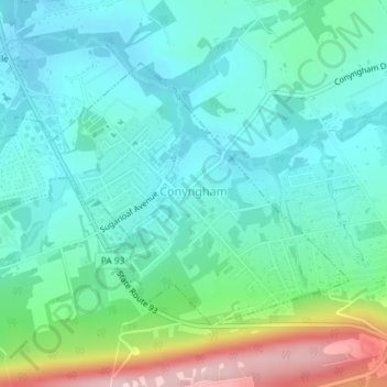
Name: Conyngham topographic map, elevation, terrain.
Average elevation: 327 m
Minimum elevation: 268 m
Maximum elevation: 510 m
Make a donation
Gear up for your next adventure:
As an Amazon Associate, this site earns from qualifying purchases at no extra cost to you.
Other topographic maps
Click on a map to view its topography, its elevation and its terrain.
Lake Leigh Dam (defunct)
United States > Pennsylvania > Luzerne County > Fairmount Township
Average elevation: 672 m
Make a donation
Gear up for your next adventure:
As an Amazon Associate, this site earns from qualifying purchases at no extra cost to you.
Solomon Gap
United States > Pennsylvania > Luzerne County > Fairview Township > Fairview
Average elevation: 479 m
Georgetown
United States > Pennsylvania > Luzerne County > Wilkes-Barre Township
Average elevation: 267 m
Make a donation
Gear up for your next adventure:
As an Amazon Associate, this site earns from qualifying purchases at no extra cost to you.
Natural Lands Trust Bear Creek Preserve - Dry Land Hill Parcel
United States > Pennsylvania > Luzerne County > Shades Glen
Average elevation: 507 m
Make a donation
Gear up for your next adventure:
As an Amazon Associate, this site earns from qualifying purchases at no extra cost to you.
Trucksville
United States > Pennsylvania > Luzerne County > Kingston Township
Average elevation: 343 m
Truesdale Terrace
United States > Pennsylvania > Luzerne County > Hanover Township
Average elevation: 319 m
Make a donation
Gear up for your next adventure:
As an Amazon Associate, this site earns from qualifying purchases at no extra cost to you.
Make a donation
Gear up for your next adventure:
As an Amazon Associate, this site earns from qualifying purchases at no extra cost to you.
Port Bowkley
United States > Pennsylvania > Luzerne County > Plains Township > Plains
Average elevation: 177 m
Nescopeck Pass
United States > Pennsylvania > Luzerne County > Nescopeck Pass
Average elevation: 427 m
Make a donation
Gear up for your next adventure:
As an Amazon Associate, this site earns from qualifying purchases at no extra cost to you.
West Nanticoke
United States > Pennsylvania > Luzerne County > West Nanticoke
Average elevation: 277 m
South Pond Dam
United States > Pennsylvania > Luzerne County > Hanover Township
Average elevation: 204 m
Scouton Lee Park
United States > Pennsylvania > Luzerne County > Wilkes-Barre > Parsons
Average elevation: 192 m
Make a donation
Gear up for your next adventure:
As an Amazon Associate, this site earns from qualifying purchases at no extra cost to you.
Huntington Creek
United States > Pennsylvania > Luzerne County > Pleasant Valley
Average elevation: 308 m
Make a donation
Gear up for your next adventure:
As an Amazon Associate, this site earns from qualifying purchases at no extra cost to you.