
Thank you for supporting this site ❤️
Make a donation
Make a donation
Gear up for your next adventure:
As an Amazon Associate, this site earns from qualifying purchases at no extra cost to you.
Haitz topographic map
Click on the map to display elevation.
Thank you for supporting this site ❤️
Make a donation
Make a donation
Gear up for your next adventure:
As an Amazon Associate, this site earns from qualifying purchases at no extra cost to you.
About this map
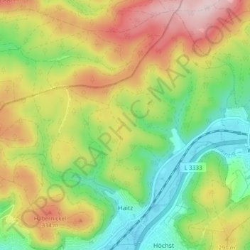
Name: Haitz topographic map, elevation, terrain.
Location: Haitz, Gelnhausen, Main-Kinzig-Kreis, Hessen, Deutschland (50.20592 9.18275 50.24894 9.25687)
Average elevation: 253 m
Minimum elevation: 128 m
Maximum elevation: 414 m
Thank you for supporting this site ❤️
Make a donation
Make a donation
Gear up for your next adventure:
As an Amazon Associate, this site earns from qualifying purchases at no extra cost to you.