
Make a donation
Gear up for your next adventure:
As an Amazon Associate, this site earns from qualifying purchases at no extra cost to you.
Hainstadt topographic map
Click on the map to display elevation.
Make a donation
Gear up for your next adventure:
As an Amazon Associate, this site earns from qualifying purchases at no extra cost to you.
About this map
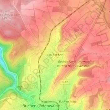
Name: Hainstadt topographic map, elevation, terrain.
Average elevation: 391 m
Minimum elevation: 274 m
Maximum elevation: 454 m
Make a donation
Gear up for your next adventure:
As an Amazon Associate, this site earns from qualifying purchases at no extra cost to you.
Other topographic maps
Click on a map to view its topography, its elevation and its terrain.
Eberstadt
Deutschland > Baden-Württemberg > Neckar-Odenwald-Kreis > Buchen (Odenwald)
Average elevation: 352 m
Rinschheim
Deutschland > Baden-Württemberg > Neckar-Odenwald-Kreis > Buchen (Odenwald)
Average elevation: 400 m
Götzingen
Deutschland > Baden-Württemberg > Neckar-Odenwald-Kreis > Buchen (Odenwald)
Average elevation: 360 m