Geolocate

Coll topographic map

Click on the map to display elevation.

About this map

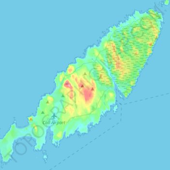
Name: Coll topographic map, elevation, terrain.

Location: Coll, Arinagour, Argyll and Bute, Scotland, United Kingdom (56.56271 -6.71045 56.69175 -6.45094)

Average elevation: 7 m

Minimum elevation: -1 m

Maximum elevation: 98 m

Gear up for your next adventure:

🔗Locking Carabiners - Secure gear to your pack or for light climbing
🩹Compact First Aid Kits - Treat blisters and minor injuries on the trail
🍁Eco‑Friendly Outdoor Products - Sustainable outdoor gear
🧯Camp Safety Kits - All‑in‑one safety gear
🥽UV Protection Sunglasses - Protect eyes on bright days

As an Amazon Associate, this site earns from qualifying purchases at no extra cost to you.