
Make a donation
Gear up for your next adventure:
As an Amazon Associate, this site earns from qualifying purchases at no extra cost to you.
Mount Wilis topographic map
Click on the map to display elevation.
Make a donation
Gear up for your next adventure:
As an Amazon Associate, this site earns from qualifying purchases at no extra cost to you.
Mount Wilis
Mount Wilis is a dormant solitary stratovolcano surrounded by low-elevation plains. It is located in East Java, Java island, Indonesia. Like most volcanoes along the Java trench, Mount Wilis is the result of subduction as the Indo-Australian plate subducts under the Sunda plate at around 6.7 cm/yr.
Make a donation
Gear up for your next adventure:
As an Amazon Associate, this site earns from qualifying purchases at no extra cost to you.
About this map
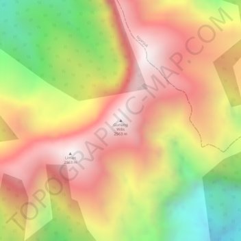
Name: Mount Wilis topographic map, elevation, terrain.
Location: Mount Wilis, Ponorogo, East Java, Java, Indonesia (-7.82064 111.75711 -7.82054 111.75721)
Average elevation: 2,147 m
Minimum elevation: 1,583 m
Maximum elevation: 2,530 m
Make a donation
Gear up for your next adventure:
As an Amazon Associate, this site earns from qualifying purchases at no extra cost to you.
Other topographic maps
Click on a map to view its topography, its elevation and its terrain.