
Make a donation
Gear up for your next adventure:
As an Amazon Associate, this site earns from qualifying purchases at no extra cost to you.
Lichtenstein topographic map
Click on the map to display elevation.
Make a donation
Gear up for your next adventure:
As an Amazon Associate, this site earns from qualifying purchases at no extra cost to you.
Lichtenstein
The municipality (Gemeinde) of Lichtenstein covers 34.24 square kilometres (13.22 sq mi) of the Reutlingen district, in the state of the Federal Republic of Germany. It is physically located in the middle of the Swabian Jura, on the edge of the Middle Kuppenalb [de] in the valley of the river Echaz. Elevation above sea level ranges from 466 meters (1,529 ft) to 836 meters (2,743 ft) Normalnull.
Make a donation
Gear up for your next adventure:
As an Amazon Associate, this site earns from qualifying purchases at no extra cost to you.
About this map
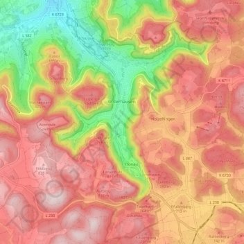
Name: Lichtenstein topographic map, elevation, terrain.
Average elevation: 689 m
Minimum elevation: 428 m
Maximum elevation: 863 m
Make a donation
Gear up for your next adventure:
As an Amazon Associate, this site earns from qualifying purchases at no extra cost to you.
Other topographic maps
Click on a map to view its topography, its elevation and its terrain.
Kleinengstingen
Germany > Baden-Württemberg > Landkreis Reutlingen > Kleinengstingen
Average elevation: 730 m
Engstingen
Germany > Baden-Württemberg > Landkreis Reutlingen
Engstingen is located on the northern edge of the Swabian Jura, at 680–750 metres (2,230–2,460 ft) altitude on the Alb plateau near the Alb edge in the valley of Ur-Lauter, about 15 km south of the town Reutlingen.
Average elevation: 738 m
Make a donation
Gear up for your next adventure:
As an Amazon Associate, this site earns from qualifying purchases at no extra cost to you.