
Threekingham topographic map
Click on the map to display elevation.
About this map
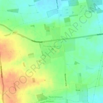
Name: Threekingham topographic map, elevation, terrain.
Average elevation: 30 m
Minimum elevation: 12 m
Maximum elevation: 52 m
Other topographic maps
Click on a map to view its topography, its elevation and its terrain.
Threekingham
United Kingdom > England > Lincolnshire > North Kesteven > Threekingham
Average elevation: 22 m
Three Kings Deer
United Kingdom > England > Lincolnshire > North Kesteven > Threekingham
Average elevation: 24 m