
Make a donation
Gear up for your next adventure:
As an Amazon Associate, this site earns from qualifying purchases at no extra cost to you.
Cranfield topographic map
Click on the map to display elevation.
Make a donation
Gear up for your next adventure:
As an Amazon Associate, this site earns from qualifying purchases at no extra cost to you.
About this map
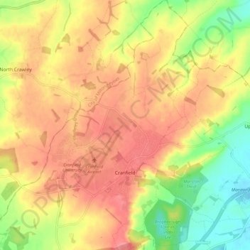
Name: Cranfield topographic map, elevation, terrain.
Location: Cranfield, Central Bedfordshire, England, United Kingdom (52.05026 -0.65807 52.11068 -0.57832)
Average elevation: 88 m
Minimum elevation: 42 m
Maximum elevation: 121 m
Make a donation
Gear up for your next adventure:
As an Amazon Associate, this site earns from qualifying purchases at no extra cost to you.
Other topographic maps
Click on a map to view its topography, its elevation and its terrain.
Little Billington
United Kingdom > England > Central Bedfordshire > Great Billington > Little Billington
Average elevation: 92 m
Make a donation
Gear up for your next adventure:
As an Amazon Associate, this site earns from qualifying purchases at no extra cost to you.