
Thank you for supporting this site ❤️
Make a donation
Make a donation
Gear up for your next adventure:
As an Amazon Associate, this site earns from qualifying purchases at no extra cost to you.
Franklin topographic map
Click on the map to display elevation.
Thank you for supporting this site ❤️
Make a donation
Make a donation
Gear up for your next adventure:
As an Amazon Associate, this site earns from qualifying purchases at no extra cost to you.
About this map
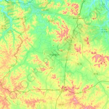
Name: Franklin topographic map, elevation, terrain.
Location: Franklin, Williamson County, Tennessee, 36711, United States (35.76521 -87.02894 36.08521 -86.70894)
Average elevation: 231 m
Minimum elevation: 148 m
Maximum elevation: 377 m
Thank you for supporting this site ❤️
Make a donation
Make a donation
Gear up for your next adventure:
As an Amazon Associate, this site earns from qualifying purchases at no extra cost to you.
Other topographic maps
Click on a map to view its topography, its elevation and its terrain.
Jim Warren Park
United States > Tennessee > Williamson County > Franklin > Westfield Estates
Average elevation: 207 m