
Make a donation
Gear up for your next adventure:
As an Amazon Associate, this site earns from qualifying purchases at no extra cost to you.
Mädelegabel topographic map
Click on the map to display elevation.
Make a donation
Gear up for your next adventure:
As an Amazon Associate, this site earns from qualifying purchases at no extra cost to you.
Mädelegabel
Zusammen mit der niedrigeren Trettachspitze (2595 m ü. NHN) und der höheren Hochfrottspitze (2649 m ü. NHN) bildet die Mädelegabel das oft bewunderte Dreigestirn oberhalb von Einödsbach. Der Name stammt von Mähder (eine gemähte Bergwiese) in der Nähe; Gabel rührt vom Erscheinungsbild des Dreigestirns nach Norden, das an eine Gabel erinnert. Ursprünglich war Mädelegabel die Bezeichnung für alle drei Gipfel des Dreigestirns, erst später erfolgte eine Unterscheidung.
Make a donation
Gear up for your next adventure:
As an Amazon Associate, this site earns from qualifying purchases at no extra cost to you.
About this map
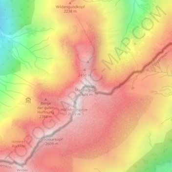
Name: Mädelegabel topographic map, elevation, terrain.
Average elevation: 2,094 m
Minimum elevation: 1,252 m
Maximum elevation: 2,612 m
Make a donation
Gear up for your next adventure:
As an Amazon Associate, this site earns from qualifying purchases at no extra cost to you.
Other topographic maps
Click on a map to view its topography, its elevation and its terrain.
Schlappolt
Deutschland > Bayern > Landkreis Oberallgäu > Oberstdorf
Das 163,43 ha große Gebiet mit der Nr. NSG-00298.01 wurde im Jahr 1986 unter Naturschutz gestellt. Es ist in Bayern der einzige Flyschbereich, der nahezu die alpine Höhenstufe erreicht.
Average elevation: 1,587 m