
Sundon topographic map
Click on the map to display elevation.
About this map
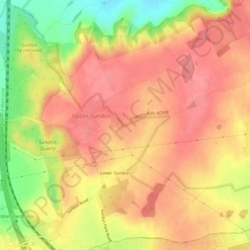
Name: Sundon topographic map, elevation, terrain.
Location: Sundon, Central Bedfordshire, England, United Kingdom (51.92293 -0.49644 51.95256 -0.44755)
Average elevation: 138 m
Minimum elevation: 83 m
Maximum elevation: 166 m
Other topographic maps
Click on a map to view its topography, its elevation and its terrain.
Lower Caldecote
United Kingdom > England > Central Bedfordshire > Upper Caldecote
Average elevation: 32 m
Dog Kennel Down
United Kingdom > England > Central Bedfordshire > Houghton Regis
Average elevation: 138 m
Dunstable Downs
United Kingdom > England > Central Bedfordshire > Church End
Because of its elevation, Dunstable Downs hosted a station in the shutter telegraph chain which connected the Admiralty in London to its naval ships in the port of Great Yarmouth during the years 1808 to 1814.
Average elevation: 178 m
Edgecote
United Kingdom > England > Central Bedfordshire > Caddington > Aley Green
Average elevation: 168 m
Houghton Hall Park
United Kingdom > England > Central Bedfordshire > Houghton Regis
Average elevation: 134 m
RSPB The Lodge nature reserve
United Kingdom > England > Central Bedfordshire > Sandy > Beeston > Seddington
Average elevation: 42 m
Totternhoe Knolls
United Kingdom > England > Central Bedfordshire > Church End > Lower End
Average elevation: 105 m
Crawley Park
United Kingdom > England > Central Bedfordshire > Aspley Guise > Husborne Crawley
Average elevation: 98 m