
Make a donation
Gear up for your next adventure:
As an Amazon Associate, this site earns from qualifying purchases at no extra cost to you.
Elva topographic map
Click on the map to display elevation.
Make a donation
Gear up for your next adventure:
As an Amazon Associate, this site earns from qualifying purchases at no extra cost to you.
About this map
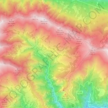
Name: Elva topographic map, elevation, terrain.
Location: Elva, Cuneo, Piemont, Italien (44.51427 7.02137 44.56854 7.12803)
Average elevation: 1,799 m
Minimum elevation: 924 m
Maximum elevation: 2,482 m
Make a donation
Gear up for your next adventure:
As an Amazon Associate, this site earns from qualifying purchases at no extra cost to you.
Other topographic maps
Click on a map to view its topography, its elevation and its terrain.
Make a donation
Gear up for your next adventure:
As an Amazon Associate, this site earns from qualifying purchases at no extra cost to you.
Make a donation
Gear up for your next adventure:
As an Amazon Associate, this site earns from qualifying purchases at no extra cost to you.
Monviso
Italien > Piemont > Cuneo > Pontechianale
Den Normalweg, der über die Südseite auf den Gipfel führt, erreicht man von Osten (Italien) vom Ausgangsort Crissolo im oberen Po-Tal über die Hütten Pian del Re und Quintino Sella am See Lago Grande di Viso (2640 m). Von Westen (Frankreich) erreicht man den Normalweg über die Hütte Rifugio Vallanta.…
Average elevation: 2,985 m
Make a donation
Gear up for your next adventure:
As an Amazon Associate, this site earns from qualifying purchases at no extra cost to you.
Make a donation
Gear up for your next adventure:
As an Amazon Associate, this site earns from qualifying purchases at no extra cost to you.