
Southern Nantahala Wilderness topographic map
Interactive map
Click on the map to display elevation.
About this map
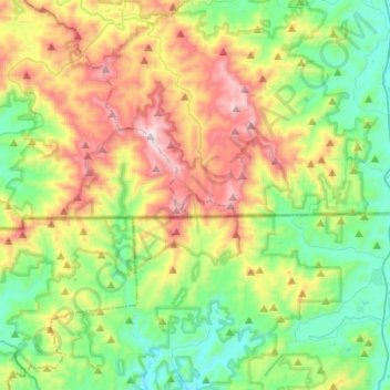
Name: Southern Nantahala Wilderness topographic map, elevation, terrain.
Average elevation: 957 m
Minimum elevation: 584 m
Maximum elevation: 1,657 m
Other topographic maps
Click on a map to view its topography, its elevation and its terrain.
Asheville
USA > North Carolina > Asheville
Asheville, Buncombe County, North Carolina, USA
Average elevation: 727 m
Tar River
USA > North Carolina > Greenville
Tar River, Greenville, Pitt County, North Carolina, 27834, USA
Average elevation: 6 m
Allegheny
USA > North Carolina > Allegheny
Allegheny, Madison County, North Carolina, USA
Average elevation: 797 m
Mount Mitchell
Mount Mitchell, Yancey County, North Carolina, USA
Average elevation: 1,743 m
Kings Mountain
USA > North Carolina > Kings Mountain
Kings Mountain, Cleveland County, North Carolina, 28086, USA
Average elevation: 272 m
Downs Mountain
Downs Mountain, Macon County, North Carolina, 28763, USA
Average elevation: 732 m