
Make a donation
Gear up for your next adventure:
As an Amazon Associate, this site earns from qualifying purchases at no extra cost to you.
Kandern topographic map
Click on the map to display elevation.
Make a donation
Gear up for your next adventure:
As an Amazon Associate, this site earns from qualifying purchases at no extra cost to you.
About this map
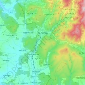
Name: Kandern topographic map, elevation, terrain.
Average elevation: 450 m
Minimum elevation: 250 m
Maximum elevation: 1,019 m
Make a donation
Gear up for your next adventure:
As an Amazon Associate, this site earns from qualifying purchases at no extra cost to you.
Other topographic maps
Click on a map to view its topography, its elevation and its terrain.
Obertüllingen
Germany > Baden-Württemberg > Landkreis Lörrach > Lörrach > Untertüllingen
Average elevation: 307 m
Nordschwaben
Germany > Baden-Württemberg > Landkreis Lörrach > Rheinfelden (Baden)
Average elevation: 446 m
Lippisbacher Hof
Germany > Baden-Württemberg > Landkreis Lörrach > Obereggenen
Average elevation: 645 m
Make a donation
Gear up for your next adventure:
As an Amazon Associate, this site earns from qualifying purchases at no extra cost to you.
Elbenschwand
Germany > Baden-Württemberg > Landkreis Lörrach > Kleines Wiesental
Average elevation: 789 m
Make a donation
Gear up for your next adventure:
As an Amazon Associate, this site earns from qualifying purchases at no extra cost to you.