
Make a donation
Gear up for your next adventure:
As an Amazon Associate, this site earns from qualifying purchases at no extra cost to you.
Le Planet topographic map
Click on the map to display elevation.
Make a donation
Gear up for your next adventure:
As an Amazon Associate, this site earns from qualifying purchases at no extra cost to you.
About this map
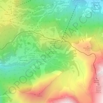
Name: Le Planet topographic map, elevation, terrain.
Average elevation: 1,699 m
Minimum elevation: 1,015 m
Maximum elevation: 2,612 m
Make a donation
Gear up for your next adventure:
As an Amazon Associate, this site earns from qualifying purchases at no extra cost to you.
Other topographic maps
Click on a map to view its topography, its elevation and its terrain.
Saint-Nicolas-de-Véroce
France > Auvergne-Rhône-Alpes > Haute-Savoie > Saint-Gervais-les-Bains
Average elevation: 1,559 m
Glacier de Miage
France > Auvergne-Rhône-Alpes > Haute-Savoie > Saint-Gervais-les-Bains
Average elevation: 2,744 m
Lac glaciaire de Bionnassay
France > Auvergne-Rhône-Alpes > Haute-Savoie > Saint-Gervais-les-Bains
Average elevation: 1,993 m
Bionnassay
France > Auvergne-Rhône-Alpes > Haute-Savoie > Saint-Gervais-les-Bains
Average elevation: 1,587 m
Make a donation
Gear up for your next adventure:
As an Amazon Associate, this site earns from qualifying purchases at no extra cost to you.
Le Planet
France > Auvergne-Rhône-Alpes > Haute-Savoie > Saint-Gervais-les-Bains > Le Planet
Average elevation: 1,644 m