
Make a donation
Gear up for your next adventure:
As an Amazon Associate, this site earns from qualifying purchases at no extra cost to you.
Kasara topographic map
Click on the map to display elevation.
Make a donation
Gear up for your next adventure:
As an Amazon Associate, this site earns from qualifying purchases at no extra cost to you.
About this map
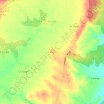
Name: Kasara topographic map, elevation, terrain.
Location: Kasara, Karauli Tehsil, Karauli, Rajasthan, 322242, India (26.57624 77.19277 26.61624 77.23277)
Average elevation: 307 m
Minimum elevation: 275 m
Maximum elevation: 331 m
Make a donation
Gear up for your next adventure:
As an Amazon Associate, this site earns from qualifying purchases at no extra cost to you.
Other topographic maps
Click on a map to view its topography, its elevation and its terrain.
karauli
India > Rajasthan > Karauli Tehsil
Karauli is located at 26°30′N 77°01′E / 26.5°N 77.02°E / 26.5; 77.02. It has an average elevation of 275 metres (902 ft).
Average elevation: 273 m