
Make a donation
Gear up for your next adventure:
As an Amazon Associate, this site earns from qualifying purchases at no extra cost to you.
Batagay topographic map
Click on the map to display elevation.
Make a donation
Gear up for your next adventure:
As an Amazon Associate, this site earns from qualifying purchases at no extra cost to you.
About this map
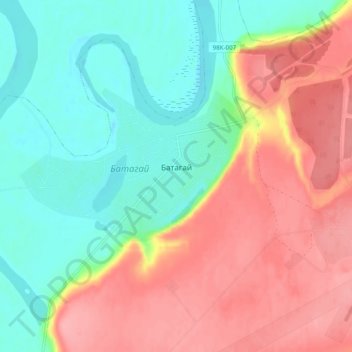
Name: Batagay topographic map, elevation, terrain.
Average elevation: 164 m
Minimum elevation: 119 m
Maximum elevation: 218 m
Make a donation
Gear up for your next adventure:
As an Amazon Associate, this site earns from qualifying purchases at no extra cost to you.
Other topographic maps
Click on a map to view its topography, its elevation and its terrain.
Verkhoyansk
Russia > Sakha Republic > Verkhoyansky Ulus
In this area, temperature inversions consistently form in winter due to the extremely cold and dense air of the Siberian High pooling in deep hollows, so that temperatures increase rather than decrease with higher altitude. In Verkhoyansk it sometimes happens that the average minimum temperatures for January,…
Average elevation: 140 m