
Bertheaume topographic map
Interactive map
Click on the map to display elevation.
About this map
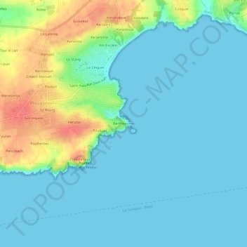
Name: Bertheaume topographic map, elevation, terrain.
Average elevation: 14 m
Minimum elevation: 0 m
Maximum elevation: 59 m
Other topographic maps
Click on a map to view its topography, its elevation and its terrain.
Plage du Trez-Hir
France > Bretagne > Finistère > Plougonvelin > Keledern
Plage du Trez-Hir, Keledern, Plougonvelin, Brest, Finistère, Bretagne, France métropolitaine, 29217, France
Average elevation: 26 m
Poulyot
France > Bretagne > Finistère > Plougonvelin
Poulyot, Plougonvelin, Brest, Finistère, Bretagne, France métropolitaine, 29217, France
Average elevation: 26 m
Pointe Saint-Mathieu
France > Bretagne > Finistère > Plougonvelin > Saint-Mathieu
Pointe Saint-Mathieu, Saint-Mathieu, Plougonvelin, Brest, Finistère, Bretagne, France métropolitaine, 29217, France
Average elevation: 8 m
Creach Manuel
France > Bretagne > Finistère > Plougonvelin
Creach Manuel, Plougonvelin, Brest, Finistère, Bretagne, France métropolitaine, 29217, France
Average elevation: 29 m
Batterie Basse de 95mm
France > Bretagne > Finistère > Plougonvelin > Poulizan
Batterie Basse de 95mm, Sentier Côtier Trez-Hir - Pointe de Saint-Mathieu, Poulizan, Plougonvelin, Brest, Finistère, Bretagne, France métropolitaine, 29217, France
Average elevation: 12 m