
Sugarloaf Hill topographic map
Interactive map
Click on the map to display elevation.
About this map
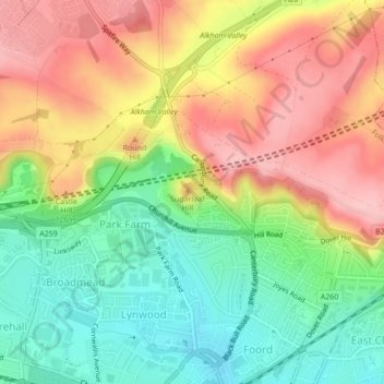
Name: Sugarloaf Hill topographic map, elevation, terrain.
Average elevation: 90 m
Minimum elevation: 17 m
Maximum elevation: 169 m
Other topographic maps
Click on a map to view its topography, its elevation and its terrain.
Lympne
United Kingdom > England > Folkestone and Hythe > Lympne
Lympne, Folkestone and Hythe, Kent, South East, England, CT21 4JG, United Kingdom
Average elevation: 53 m
Folkestone and Hythe
United Kingdom > England > Folkestone and Hythe
Folkestone and Hythe, Kent, South East, England, United Kingdom
Average elevation: 40 m