
Make a donation
Gear up for your next adventure:
As an Amazon Associate, this site earns from qualifying purchases at no extra cost to you.
Chetwynd topographic map
Click on the map to display elevation.
Make a donation
Gear up for your next adventure:
As an Amazon Associate, this site earns from qualifying purchases at no extra cost to you.
Chetwynd
Carved out of an ancient floodplain, the small terrace upon which Chetwynd is situated lies in the northern foothills of the Rocky Mountains. Once used as a grazing spot by nomadic Aboriginals, the terrace was farmed by settlers until it was developed into a town. Two types of soil—namely, the Widmark and Centurion Series—comprise the terrace's surface. The Widmark Series—a moderately well-drained degraded loamy, woody, silty, and clay-like soil—lies north of Highway 97. Meanwhile, the Centurion Series—which lies south of the highway—is a poorly drained soil with a dark-brown peaty surface material consisting of decomposed leaves and mosses. These soils, also limited by topography and stoniness, are generally used for forage and pasture.[15][16]
Make a donation
Gear up for your next adventure:
As an Amazon Associate, this site earns from qualifying purchases at no extra cost to you.
About this map
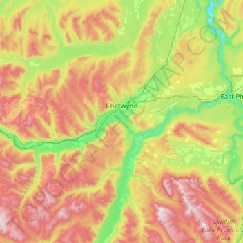
Name: Chetwynd topographic map, elevation, terrain.
Average elevation: 910 m
Minimum elevation: 469 m
Maximum elevation: 1,660 m
Make a donation
Gear up for your next adventure:
As an Amazon Associate, this site earns from qualifying purchases at no extra cost to you.
Other topographic maps
Click on a map to view its topography, its elevation and its terrain.
Pine River
Canada > British Columbia > Peace River Regional District > Area E (Moberly Lake/Sukunka Valley)
Average elevation: 973 m
Parkland
Canada > British Columbia > Peace River Regional District > Area D (Kiskatinaw Valley)
Average elevation: 726 m
Jack Lake
Canada > British Columbia > Peace River Regional District > Area B (Finlay Valley/Beatton Valley)
Average elevation: 996 m
Crescent Park
Canada > British Columbia > Peace River Regional District > Dawson Creek
Average elevation: 687 m
Make a donation
Gear up for your next adventure:
As an Amazon Associate, this site earns from qualifying purchases at no extra cost to you.
Milligan Hills
Canada > British Columbia > Peace River Regional District > Area B (Finlay Valley/Beatton Valley)
Average elevation: 891 m
Carbon Peak
Canada > British Columbia > Peace River Regional District > Area E (Moberly Lake/Sukunka Valley)
Average elevation: 1,421 m
Attachie
Canada > British Columbia > Peace River Regional District > Area B (Finlay Valley/Beatton Valley)
Average elevation: 477 m
Rocky Mountains
Canada > British Columbia > Peace River Regional District > Area D (Kiskatinaw Valley)
Average elevation: 1,458 m
Make a donation
Gear up for your next adventure:
As an Amazon Associate, this site earns from qualifying purchases at no extra cost to you.
Groundbirch
Canada > British Columbia > Peace River Regional District > Area E (Moberly Lake/Sukunka Valley)
Average elevation: 741 m
Montney
Canada > British Columbia > Peace River Regional District > Area B (Finlay Valley/Beatton Valley)
It lies at an elevation of 700 meters (2,300 ft), along the BC Rail tracks.
Average elevation: 718 m
Mount Russel
Canada > British Columbia > Peace River Regional District > Area B (Finlay Valley/Beatton Valley)
Average elevation: 1,651 m
Windfall Lake
Canada > British Columbia > Peace River Regional District > Area E (Moberly Lake/Sukunka Valley)
Average elevation: 1,655 m
Make a donation
Gear up for your next adventure:
As an Amazon Associate, this site earns from qualifying purchases at no extra cost to you.
Buckinghorse River
Canada > British Columbia > Peace River Regional District > Area B (Finlay Valley/Beatton Valley)
Average elevation: 945 m
Beaver Lake
Canada > British Columbia > Peace River Regional District > Area E (Moberly Lake/Sukunka Valley)
Average elevation: 692 m
Mount Ulysses
Canada > British Columbia > Peace River Regional District > Area B (Finlay Valley/Beatton Valley)
Average elevation: 2,355 m
Pine Valley
Canada > British Columbia > Peace River Regional District > Area D (Kiskatinaw Valley)
Average elevation: 766 m
Make a donation
Gear up for your next adventure:
As an Amazon Associate, this site earns from qualifying purchases at no extra cost to you.
Milligan Hills Provincial Park
Canada > British Columbia > Peace River Regional District > Area B (Finlay Valley/Beatton Valley)
Average elevation: 875 m
Martin Falls
Canada > British Columbia > Peace River Regional District > Area E (Moberly Lake/Sukunka Valley)
Average elevation: 763 m
Charlie Lake
Canada > British Columbia > Peace River Regional District > Area B (Finlay Valley/Beatton Valley)
Average elevation: 761 m
Indian Head
Canada > British Columbia > Peace River Regional District > Area E (Moberly Lake/Sukunka Valley)
Average elevation: 1,101 m
Make a donation
Gear up for your next adventure:
As an Amazon Associate, this site earns from qualifying purchases at no extra cost to you.
Omineca Mountains
Canada > British Columbia > Peace River Regional District > Area B (Finlay Valley/Beatton Valley)
Average elevation: 1,010 m
Cassiar Mountains
Canada > British Columbia > Peace River Regional District > Area B (Finlay Valley/Beatton Valley)
Average elevation: 935 m
Mount Jarvis
Canada > British Columbia > Peace River Regional District > Area D (Kiskatinaw Valley)
Average elevation: 1,777 m
Rocky Mountains
Canada > British Columbia > Peace River Regional District > Area B (Finlay Valley/Beatton Valley)
Average elevation: 1,019 m
Make a donation
Gear up for your next adventure:
As an Amazon Associate, this site earns from qualifying purchases at no extra cost to you.
Obo Lake
Canada > British Columbia > Peace River Regional District > Area B (Finlay Valley/Beatton Valley)
Average elevation: 1,300 m
Clayhurst
Canada > British Columbia > Peace River Regional District > Area B (Finlay Valley/Beatton Valley)
Average elevation: 644 m
Fort St. John
Canada > British Columbia > Peace River Regional District > Fort St. John
Average elevation: 650 m
East Pine
Canada > British Columbia > Peace River Regional District > Area E (Moberly Lake/Sukunka Valley)
Average elevation: 664 m
Make a donation
Gear up for your next adventure:
As an Amazon Associate, this site earns from qualifying purchases at no extra cost to you.
Buckinghorse River
Canada > British Columbia > Peace River Regional District > Area B (Finlay Valley/Beatton Valley)
Average elevation: 1,200 m
Rocky Mountains
Canada > British Columbia > Peace River Regional District > Area B (Finlay Valley/Beatton Valley)
Average elevation: 1,221 m
Rocky Mountains
Canada > British Columbia > Peace River Regional District > Area B (Finlay Valley/Beatton Valley)
Average elevation: 986 m
Rocky Mountains
Canada > British Columbia > Peace River Regional District > Area E (Moberly Lake/Sukunka Valley)
Average elevation: 1,462 m
Make a donation
Gear up for your next adventure:
As an Amazon Associate, this site earns from qualifying purchases at no extra cost to you.
Site C Dam
Canada > British Columbia > Peace River Regional District > Area E (Moberly Lake/Sukunka Valley)
Average elevation: 483 m
Rocky Mountains
Canada > British Columbia > Peace River Regional District > Area B (Finlay Valley/Beatton Valley)
Average elevation: 870 m
Horsetail Falls
Canada > British Columbia > Peace River Regional District > Area E (Moberly Lake/Sukunka Valley)
Average elevation: 1,024 m
Brandon Peak
Canada > British Columbia > Peace River Regional District > Area B (Finlay Valley/Beatton Valley)
Average elevation: 1,801 m
Make a donation
Gear up for your next adventure:
As an Amazon Associate, this site earns from qualifying purchases at no extra cost to you.
Rocky Mountains
Canada > British Columbia > Peace River Regional District > Area D (Kiskatinaw Valley)
Average elevation: 1,252 m
Rocky Mountains
Canada > British Columbia > Peace River Regional District > Area E (Moberly Lake/Sukunka Valley)
Average elevation: 1,462 m
Rocky Mountains
Canada > British Columbia > Peace River Regional District > Area B (Finlay Valley/Beatton Valley)
Average elevation: 1,221 m