
Rembertów topographic map
Interactive map
Click on the map to display elevation.
About this map
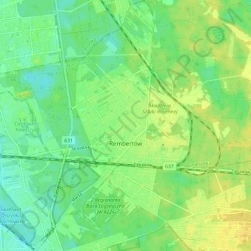
Name: Rembertów topographic map, elevation, terrain.
Location: Rembertów, Warsaw, Masovian Voivodeship, Poland (52.23908 21.10762 52.29111 21.19134)
Average elevation: 93 m
Minimum elevation: 82 m
Maximum elevation: 104 m
Other topographic maps
Click on a map to view its topography, its elevation and its terrain.
Żoliborz
Poland > Masovian Voivodeship > Warsaw
Żoliborz, Warsaw, Masovian Voivodeship, Poland
Average elevation: 95 m
Praga-Południe
Poland > Masovian Voivodeship > Warsaw
Praga-Południe, Warsaw, Masovian Voivodeship, Poland
Average elevation: 86 m
Śródmieście
Poland > Masovian Voivodeship > Warsaw
Śródmieście, Warsaw, Warszawa, Masovian Voivodeship, Poland
Average elevation: 101 m