
Florida topographic map
Interactive map
Click on the map to display elevation.
About this map
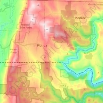
Name: Florida topographic map, elevation, terrain.
Average elevation: 525 m
Minimum elevation: 189 m
Maximum elevation: 859 m
Florida is a town in Berkshire County, Massachusetts, United States. It is part of the Pittsfield, Massachusetts Metropolitan Statistical Area. It is home to the east portal of the Hoosac Tunnel, as well as Whitcomb Summit (elevation 2,172 ft or 662 m), the highest point of the Mohawk Trail. Florida contains the village of Drury. At the 2010 census the town had a total population of 752.