
Chautauqua County topographic map
Interactive map
Click on the map to display elevation.
About this map
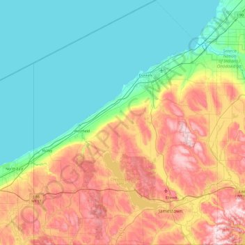
Name: Chautauqua County topographic map, elevation, terrain.
Location: Chautauqua County, New York, United States of America (41.99833 -79.76194 42.69143 -79.06078)
Average elevation: 328 m
Minimum elevation: 170 m
Maximum elevation: 668 m
The county is generally composed of rolling hills and valleys, with elevations ranging anywhere between 1100 and 2100 feet, although the land within a few miles of Lake Erie is generally flat and at an elevation of 1000 feet or lower. The lowest point in the county is Lake Erie, at 571 feet (174 meters), and the highest point is Gurnsey Benchmark at 2180 feet (664 meters).
Other topographic maps
Click on a map to view its topography, its elevation and its terrain.
Ulster
United States of America > New York
Ulster, New York, United States of America
Average elevation: 343 m
Saint Lawrence
United States of America > New York
Saint Lawrence, New York, United States of America
Average elevation: 239 m
Chenango County
United States of America > New York
Chenango County, New York, United States of America
Average elevation: 442 m
Parish
United States of America > New York > Parish
Parish, Town of Parish, Oswego County, New York, 13131, United States of America
Average elevation: 147 m
Town of Onondaga
United States of America > New York
Town of Onondaga, Onondaga County, New York, 13215, United States of America
Average elevation: 266 m
Essex County
United States of America > New York
Essex County, New York, United States of America
Average elevation: 418 m
Westchester
United States of America > New York
Westchester, New York, United States of America
Average elevation: 95 m
Farmingville
United States of America > New York > Farmingville
Farmingville, Suffolk County, New York, 11738, United States of America
Average elevation: 47 m
Saratoga County
United States of America > New York
Saratoga County, New York, United States of America
Average elevation: 218 m
Niagara Falls
United States of America > New York > Niagara Falls
Niagara Falls, Niagara County, New York, United States of America
Average elevation: 180 m
Suffolk County
United States of America > New York
Suffolk County, New York, United States of America
Average elevation: 36 m