
Make a donation
Gear up for your next adventure:
As an Amazon Associate, this site earns from qualifying purchases at no extra cost to you.
Massakory topographic map
Click on the map to display elevation.
Make a donation
Gear up for your next adventure:
As an Amazon Associate, this site earns from qualifying purchases at no extra cost to you.
About this map
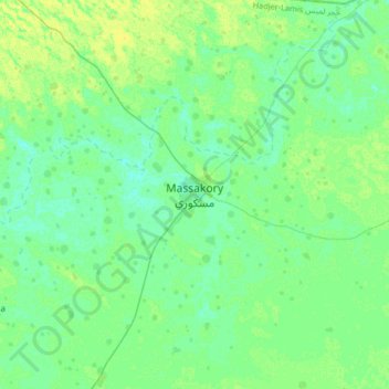
Name: Massakory topographic map, elevation, terrain.
Location: Massakory, Hadjer-Lamis, Tchad (12.83649 15.57491 13.15649 15.89491)
Average elevation: 288 m
Minimum elevation: 283 m
Maximum elevation: 296 m
Make a donation
Gear up for your next adventure:
As an Amazon Associate, this site earns from qualifying purchases at no extra cost to you.
Other topographic maps
Click on a map to view its topography, its elevation and its terrain.
Lac Tchad
Le projet d'origine formalisé au début des années 1990 prévoyait de barrer les cours de plusieurs rivières importantes du nord-est de la République démocratique du Congo au moyen de barrages de régulation, et de soustraire une partie de leurs débits pour les amener vers un lac artificiel construit sur…
Average elevation: 282 m