
Make a donation
Gear up for your next adventure:
As an Amazon Associate, this site earns from qualifying purchases at no extra cost to you.
Erkeln topographic map
Click on the map to display elevation.
Make a donation
Gear up for your next adventure:
As an Amazon Associate, this site earns from qualifying purchases at no extra cost to you.
About this map
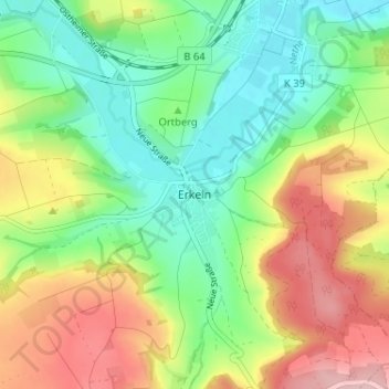
Name: Erkeln topographic map, elevation, terrain.
Location: Erkeln, Brakel, Kreis Höxter, Nordrhein-Westfalen, Deutschland (51.66830 9.20646 51.70830 9.24646)
Average elevation: 187 m
Minimum elevation: 111 m
Maximum elevation: 302 m
Make a donation
Gear up for your next adventure:
As an Amazon Associate, this site earns from qualifying purchases at no extra cost to you.
Other topographic maps
Click on a map to view its topography, its elevation and its terrain.
Auenhausen
Deutschland > Nordrhein-Westfalen > Kreis Höxter > Brakel
Auenhausen liegt auf einem Höhenzug zwischen dem Eggegebirge und der Weser, über 300 m N.N. Von Auenhausen hat man einen Ausblick im Norden bis zum Köterberg und im Süden bis zum Desenberg. Der Ort besitzt eine Feldflur von 350 ha.
Average elevation: 271 m
Make a donation
Gear up for your next adventure:
As an Amazon Associate, this site earns from qualifying purchases at no extra cost to you.