
Thank you for supporting this site ❤️
Make a donation
Make a donation
Gear up for your next adventure:
As an Amazon Associate, this site earns from qualifying purchases at no extra cost to you.
Kaltes Feld topographic map
Click on the map to display elevation.
Thank you for supporting this site ❤️
Make a donation
Make a donation
Gear up for your next adventure:
As an Amazon Associate, this site earns from qualifying purchases at no extra cost to you.
Kaltes Feld
Das Kalte Feld ist mit 781,1 m ü. NHN die höchste Erhebung in Ostwürttemberg. Die nächste höhere Erhebung ist der 23 km südwestlich gelegene Boßler.
Thank you for supporting this site ❤️
Make a donation
Make a donation
Gear up for your next adventure:
As an Amazon Associate, this site earns from qualifying purchases at no extra cost to you.
About this map
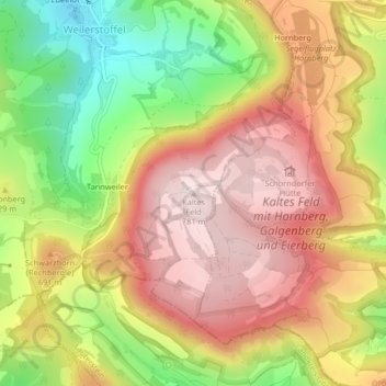
Name: Kaltes Feld topographic map, elevation, terrain.
Average elevation: 628 m
Minimum elevation: 433 m
Maximum elevation: 782 m
Thank you for supporting this site ❤️
Make a donation
Make a donation
Gear up for your next adventure:
As an Amazon Associate, this site earns from qualifying purchases at no extra cost to you.